Building PyGPSLogger: A Python GPS Data Logger with Google Static Maps Integration
Introduction
Tracking and visualizing GPS data has applications in everything from outdoor adventures to logistics tracking. PyGPSLogger is a straightforward, Python-based GPS data logging tool that logs GPS receiver data, parses it, and then displays the recorded locations on a Google Static Map. This project leverages goompy for Google Maps integration and pynmea2 to parse raw NMEA data from GPS modules, providing an efficient way to store and visualize GPS information.
This article explores how PyGPSLogger works, from handling raw GPS data to rendering locations on a map. Whether you're creating your first GPS project or expanding your Python skillset, PyGPSLogger is a practical way to explore GPS data logging and mapping.
Project Overview
PyGPSLogger connects to a GPS receiver, logs location data, and displays logged data on Google Static Maps. With additional credits to libraries like goompy and pynmea2, PyGPSLogger makes it easy to visualize your GPS data on a map.
Key Features
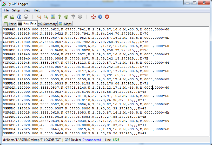
- NMEA Parsing: Parse raw data from GPS modules, which use the National Marine Electronics Association (NMEA) format for transmitting location information.
- Data Logging: Logs GPS coordinates, timestamps, and other metadata for later retrieval.
- Google Static Maps: Display logged locations on a Google Static Map to visualize movement paths.
Setting Up the Project
1. Components Needed
- Python (Python 3.x)
- GPS Module (Any GPS receiver capable of NMEA output)
- Google Maps API Key (for Google Static Maps)
- Libraries:
- goompy: For rendering Google Maps in Python.
- pynmea2: For parsing NMEA-formatted GPS data.
- led icons: For system icons if displaying status in a UI.
Libraries and Their Purpose
- pynmea2: This library parses raw NMEA sentences from the GPS receiver, making it easy to extract latitude, longitude, and other essential data.
- goompy: A simple Python wrapper for displaying Google Maps, goompy allows us to use the Google Static Maps API to visualize GPS logs.
- led icons: System icons or status indicators can be added to show the logging state, errors, or GPS connection status visually.
Step-by-Step Guide to Building PyGPSLogger
1. Setting Up Your GPS Module
Connect your GPS receiver module to your computer. Most GPS modules output data in the NMEA format, a standard text-based format for location data. Ensure your GPS receiver is correctly configured and outputting data, as PyGPSLogger will rely on this to log locations.
2. Installing Required Libraries
Use pip to install the necessary libraries:
pip install goompy pynmea2
Note: You will need a Google Maps API key for goompy to work with Google Static Maps. Visit the Google Cloud Console to create a key.
3. Parsing NMEA Data with pynmea2
The GPS module outputs data in NMEA sentences, which contain location, altitude, and satellite information. The pynmea2 library simplifies extracting this data.
Example code to parse data:
import pynmea2

def parse_nmea_data(nmea_string):
    try:
        msg = pynmea2.parse(nmea_string)
        if isinstance(msg, pynmea2.types.talker.GGA):
            print("Latitude:", msg.latitude)
            print("Longitude:", msg.longitude)
            print("Altitude:", msg.altitude)
    except pynmea2.ParseError as e:
        print("Parse error:", e)
The function above extracts latitude, longitude, and altitude data from a GGA sentence, one of the most common NMEA sentences.
4. Logging GPS Data
To log GPS data, we need to repeatedly parse NMEA sentences from the GPS receiver. Here’s a sample function that writes parsed data to a file:
import datetime

def log_gps_data(latitude, longitude):
    timestamp = datetime.datetime.now()
    with open("gps_log.csv", "a") as log_file:
        log_file.write(f"{timestamp},{latitude},{longitude}\n")
Each time a new data point is received, the logger appends the latitude, longitude, and timestamp to a CSV file, creating a record of the device’s path.
5. Displaying GPS Locations on Google Maps
Using goompy, we can load the recorded locations onto a Google Static Map. Here’s a sample function for rendering a map centered on the latest GPS coordinates:
from goompy import GooMPy

def show_location_on_map(latitude, longitude):
    api_key = "YOUR_GOOGLE_MAPS_API_KEY"
    zoom_level = 15
    goompy_instance = GooMPy(api_key, latitude, longitude, zoom=zoom_level)

    map_image = goompy_instance.get_image()
    map_image.show()  # Opens the map in the default image viewer
With each GPS log entry, the map updates to show the latest coordinates. You can also plot a trail by reading all logged locations and marking each one on the map.
6. Adding Status Icons
If you’d like to provide visual feedback (e.g., logging status or GPS fix status), you can use led icons for custom indicators. This is useful in a GUI, where you can add LED icons to indicate whether data is actively being logged or if there’s an error with the GPS connection.
Putting It All Together
You can check the Github repository below to check the combined functions to create a complete logging and display workflow
Conclusion
PyGPSLogger simplifies GPS data logging and visualization. By combining Python libraries for parsing NMEA data and displaying maps, this project demonstrates how to capture, store, and visualize GPS data effectively. This project’s modular design also makes it easy to add features, such as route calculation, path analysis, or integration with other services.
Github Repository
Check out the code repository for PyGPSLogger on GitHub to explore or contribute to this project:
This project is an excellent tool for anyone interested in tracking GPS data and learning more about GPS technology with Python!

 View on GitHub